


Akuatikisle: Jurnal Akuakultur, Pesisir dan Pulau-Pulau Kecil

Full Length Article
Analysis of shoreline changes on the northeast coast of Nunukan Island, Nunukan Regency, North Kalimantan Province
Highlights
Generate NLP AI by Wizdam ID.
Abstract
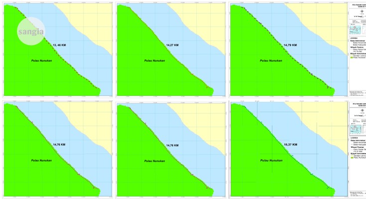
This study aimed to analyze changes in the coastline in the Northeast of Nunukan Island, North Kalimantan Province and to determine the area in the Northeast of Nunukan Island, North Kalimantan Province, which experienced changes in the coastline. This research was conducted in February - March 2022 on the Northeast Coast of Nunukan Island, North Kalimantan Province. The type of data collected is satellite imagery for the last 6 years, 2017-2022. Data were analyzed using GIS software with cropping, radiometric correction, geometric correction, image enhancement, shoreline digitization and overlay methods. The results showed that the rate of change of the eastern coastline of Nunukan Island in 2017 was 13,457.91 m long, 2018 was 14,266.82 m long, 2019 was 14,787.25 m long, 2020 was 14,762.21 m long, 2021 was 15,369.23 m long, and in 2022 it is 15,968.22 m. The area that has experienced a change in coastline on Nunukan Island, North Kalimantan Province, namely in 2017 covering an area of 21.70 ha, in 2018 covering an area of 22.27 ha, in 2019 covering an area of 23.34 ha, in 2020 covering an area of 23.74 ha, in 2021 covering an area of 24 .26 ha and in 2022 it will be 32.82 ha. This study concludes that the area of change in the coastline has changed significantly from 2017 to 2022.
Keywords
Introduction
Section snippets
Material and Methods
Materials and methods from the full-text PDF of this article cannot be displayed.
Results
Results from the full-text PDF of this article cannot be displayed.
Discussion
Discussion from the full-text PDF of this article cannot be displayed.
Conclusions
Conclusions from the full-text PDF of this article cannot be displayed.
Acknowledgment
Acknowledgment from the full-text PDF of this article cannot be displayed.
Funding Information
Dinas Perikanan dan Kelautan Kabupaten Nunukan dan Universitas Cokroaminoto Makassar
Competing interest
The authors declare that they have no known competing financial interests or personal relationships that could have appeared to influence the work reported in this paper.
Conflict of interest
The authors declare that the research was conducted in the absence of any commercial or financial relationships that could be construed as a potential conflict of interest.
Ethical approval acknowledgements
No ethical approval required for this article. All procedures followed were in accordance with the ethical standards of the responsible committee on human experimentation (institutional and national) and with the Helsinki Declaration of 1975, as revised in 2008 (5)
Supplementary files
Data sharing not applicable to this article as no datasets were generated or analysed during the current study, and/or contains supplementary material, which is available to authorized users.
References (1)
Agustin, NS; & Syah, AF. 2020. Analisis Perubahan Garis Pantai di Pulau Madura Menggunakan Citra Satelit Landsat 8. Juvenil: Jurnal Ilmiah Kelautan dan Perikanan, 1(2): 427-436, DOI: https://doi.org/10.21107/juvenil.v1i3.
Arifin, A., Awaluddin, M., Amarrohman, F. J. 2020. Analisis Pengaruh Perubahan Garis Pantai Terhadap Batas Pengelolaan Wilayah Laut Daerah Provinsi DKI Jakarta. Jurnal Geodesi Undip, 9(1): 2337-845X, DOI: https://doi.org/10.14710/jgundip.2020.26159.
Beatley. 2002. Systems Analysis and Design for the Global Enterprise Seventh Edition International Edition. McGraw. New York. ISBN:9780071107662.
Daruwedho, H., Sasmito, B., & A, F. J. 2016. Analisis Pola Arus Laut Permukaan Perairan Indonesia dengan Menggunakan Satelit ALtimetri Jason2 Tahun 2010-2014. Jurnal Geodesi, 5(2): 147–158, DOI: https://doi.org/10.14710/jgundip.2016.11531
Diposaptono, S. & Budiman. 2008. Hidup akrab dengan gempa dan tsunami. Buku Ilmiah Populer. Bogor. 383 p. ISBN: 9789791291064.
Handjojo, Z.O., T.F. Manurung, & K.P. Utomo. 2015. Perubahan garis pantai akibat kerusakan hutan mangrove di Kelurahan Terusan Kecamatan Mempawah Hilir Kabupaten Mempawah. Jurnal Mahasiswa Teknik Lingkungan, 1(1): 1-10, DOI: https://doi.org/10.29244/jitkt.v12i1.22815.
Islam, H. S., Suryoputro, A. A. D., & Handoyo, G. 2022. Studi Perubahan Garis Pantai 2017- 2021 di Pesisir Kabupaten Batang, Jawa Tengah. Jurnal Indonesian Journal of Oceanography (IJOCE), 4 (4): 19-33, DOI: 10.14710/ijoce.v4i4.15626.
Nugraha, A.W. 2008. Evaluasi Penggunaan Lahan Di Daerah Teluk Banten, Kabupaten Serang, Propinsi Banten Menggunakan Data Landsat 7 ETM+ Multi Temporal Tahun 1999 – 2005. Skripsi. Jurusan Ilmu Kelautan. Fakultas Perikanan dan Ilmu Kelautan. UNDIP, Semarang.
Pratama, M. A. P., Barus, B. S., & Putri, W. A. E. 2020. Perubahan Garis Pantai di Perairan Muara Banyuasin Kaitannya dengan Sedimentasi. Jurnal Ilmu dan Teknologi Kelautan Tropis. 12 (1): 107-118, DOI: http://doi.org/10.29244/jitkt.v12i1.28276.
Rahman, A. 2018. Modul Ajar Pengolahan Citra Digital (Studi Kasus Perubahan Lahan Mangrove dan Rawa). Universitas Lambung Mangkurat. Banjarbaru.
Suhana, M.P., I.W. Nurjaya, & N.M. Natih. 2016. Analisis kerentanan Pantai Timur Pulau Bintan, Provinsi Kepulauan Riau menggunakan digital shoreline analysis system dan metode coastal vulnerability index. Jurnal Teknologi Perikanan dan Kelautan, 7(1): 21-38. DOI: http://doi.org/10.24319/jtpk.7.21-38.
Tejakusuma I. G. 2011. Pengkajian Kerentanan Fisik Untuk Pengembangan Pesisir Wilayah Kota Makassar. Jurnal Sains dan Teknologi Indonesia, 13(2) : 82–87.
Yulius & Ramdhan, M. 2013. perubahan Garis Pantai di Teluk Bungus Kota Padang, Provinsi Sumatera Barat Berdasarkan Analisis Citra Satelit. Jurnal Ilmu dan Teknologi Kelautan Tropis, 5 (2): 417-427, DOI: https://doi.org/10.29244/jitkt.v5i2.7570
Bibliographic Information

Cite this article as:
-
Submitted
9 May 2023 -
Revised
22 May 2023 -
Accepted
29 May 2023 -
Published
30 May 2023 -
Version of record
2 June 2023 -
Issue date
30 May 2023
-
Academic subject
Ilmu Kelautan
Copyright
Wahyuti, Program Studi Agrobisnis Perikanan, Fakultas Perikanan, Universitas Cokroaminoto Makassar, Jl. Perintis Kemerdekaan Km.11 Tamalanrea, Makassar, Sulawesi Selatan 90245, Indonesia.
wahyutiasaf864@gmail.comJaya, Program Studi Akuakultur, Fakultas Perikanan, Universitas Cokroaminoto Makassar, Jl. Perintis Kemerdekaan Km.11 Tamalanrea, Makassar, Sulawesi Selatan 90245, Indonesia.
yayapunk63@gmail.comAndiUmmung, Program Studi Agrobisnis Perikanan, Fakultas Perikanan, Universitas Cokroaminoto Makassar, Jl. Perintis Kemerdekaan Km.11 Tamalanrea, Makassar, Sulawesi Selatan 90245, Indonesia.
andi.ummung@gmail.comCopyright © 2023 Wahyuti, Jaya, Andi Ummung. Sangia Research Media and Publishing. Production and hosting by Sangia (SRM™).  This work is licensed under a Creative Commons Attribution-ShareAlike 4.0 International License.
Disclaimer: All claims expressed in this article are solely those of the authors and do not necessarily represent those of their affiliated organizations, or those of the publisher, the editors and the reviewers. Any product that may be evaluated in this article or claim that may be made by its manufacturer is not guaranteed or endorsed by the publisher.
Comments on this article
By submitting a comment you agree to abide by our Terms and Community Guidelines. If you find something abusive or that does not comply with our terms or guidelines please flag it as inappropriate.